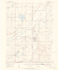
1951 Map of Erie
USGS Topo · Published 1951About this map
The coal mining landscape of the Boulder Co Weld Co border dominates this mid-century survey, revealing a region defined by extraction and irrigation. Erie sits at the heart of the sheet, surrounded by a high density of named mines including the Erie Mine, Morrison Mine, and the Black Diamond Mine near the southern edge. The presence of numerous inactive shafts, such as the Tynan Mine and State Mine, suggests a period of transition for the local industry. This industrial character is balanced by a complex network of water management features, including the Lower Boulder Ditch and Baller Lake, which supported the agricultural development around Canfield and Lafayette. The Burlington and Chicago and Quincy railroad lines cut through the terrain, providing the essential link between these mining outposts and wider markets during the early 1950s.
Find a feature on this map
47 named features on this map. Tap any name to fly to it.
Don’t see what you’re looking for? This feature index may not catch every label — zoom into the map to look around manually.
Map Details
Editions of this 1951 Erie Map
This is the sole edition of this map. No revisions or reprints were ever made.
Other maps of this area

1890 · East Denver
USGS Topo · 1:125,000

1899 · West Denver
USGS Topo · 1:125,000

1902 · Greeley
USGS Topo · 1:125,000

1904 · Niwot
USGS Topo · 1:62,500

1940 · Eastlake
USGS Topo · 1:31,680

1940 · Lafayette
USGS Topo · 1:31,680

1942 · Louisville
USGS Topo · 1:31,680

1944 · Lafayette
USGS Topo · 1:31,680

1944 · Eastlake
USGS Topo · 1:31,680

1949 · Gowanda
USGS Topo · 1:24,000