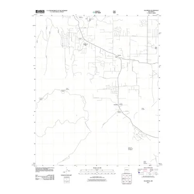
2011 Map of Escabosa
USGS Topo · Published 2011About this map
Escabosa and its neighboring communities in the Manzano Mountains are documented here during a period of steady residential growth and rural management. The map details a landscape defined by deep arroyos and canyons, such as Cañon de los Turrieta and Cañon de Rajadero de los Negros, which channel the drainage of the Cañada de Escabosa. Historic centers like Miera and Yrisarri are shown alongside more contemporary developments like Ponderosa Pine and Tranquillo Pine. This 2011 survey captures the interface between private land and public resources, anchored by the Oak Flat District Ranger Office and the Deadman Campground. Local history is preserved at the Escabosa Cemetery, while the road network, including Indian Service Route 60 and Skyland Blvd, illustrates how this high-elevation terrain has been navigated and settled over generations.
Find a feature on this map
43 named features on this map. Tap any name to fly to it.
Don’t see what you’re looking for? This feature index may not catch every label — zoom into the map to look around manually.
Map Details
Editions of this 2011 Escabosa Map
This is the sole edition of this map. No revisions or reprints were ever made.
Other maps of this area

1892 · San Pedro
USGS Topo · 1:125,000

1917 · Estancia
USGS Topo · 1:125,000

1954 · Bosque Peak
USGS Topo · 1:24,000

1954 · Chilili
USGS Topo · 1:24,000

1954 · Mount Washington
USGS Topo · 1:24,000
1954 · Tijeras
USGS Topo · 1:24,000

1954 · Sedillo
USGS Topo · 1:24,000

1954 · Tajique
USGS Topo · 1:24,000

1954 · Escabosa
USGS Topo · 1:24,000

1954 · Edgewood
USGS Topo · 1:24,000