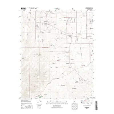
2013 Map of Escabosa
USGS Topo · Published 2013About this map
Cibola National Forest encompasses much of this high-elevation terrain where the Manzanita Mountains give way to a complex system of deep canyons. The settlement of Escabosa serves as a central hub for the area, located near the Escabosa Cem and the winding course of Cañada de Escabosa. To the north, small communities like Yrisarri, Miera, and Tranquillo Pine are tucked into the landscape along State Hwy 337. The map reveals a transition from the structured plots of Lexco Estates to the wilder reaches of Cañon Turrieta and Cañon de Oso. This 2013 survey provides an exacting look at the modern rural interface between the mountain forest and established settlements, noting landmarks like the Oak Flat District Ranger Office and several named draws including Buffalo Draw.
Find a feature on this map
105 named features on this map. Tap any name to fly to it.
Don’t see what you’re looking for? This feature index may not catch every label — zoom into the map to look around manually.
Map Details
Editions of this 2013 Escabosa Map
This is the sole edition of this map. No revisions or reprints were ever made.
Other maps of this area

1892 · San Pedro
USGS Topo · 1:125,000

1917 · Estancia
USGS Topo · 1:125,000

1954 · Bosque Peak
USGS Topo · 1:24,000

1954 · Chilili
USGS Topo · 1:24,000

1954 · Mount Washington
USGS Topo · 1:24,000
1954 · Tijeras
USGS Topo · 1:24,000

1954 · Sedillo
USGS Topo · 1:24,000

1954 · Tajique
USGS Topo · 1:24,000

1954 · Escabosa
USGS Topo · 1:24,000

1954 · Edgewood
USGS Topo · 1:24,000