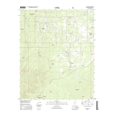
2017 Map of Escabosa
USGS Topo · Published 2017About this map
The Manzano Mountains and parts of the Cibola National Forest define the geography of this central New Mexico landscape. Small residential clusters and rural settlements such as Escabosa, Yrisarri, and Cedro are scattered along the eastern slopes, connected by a network of local roads with astronomical and avian names like Milky Way and Mockingbird Hill Rd. The terrain is deeply incised by numerous canyons and seasonal watercourses, including Largo Canyon, Charlies Canyon, and the Arroyo de Yrisarri. These canyons, such as Cañon de Chilili and Cañon de Savina, illustrate the traditional land use and drainage patterns of the region. Local history is anchored by sites like the Escabosa Cem, while the western edge of the map touches the military boundary of Kirtland AFB, showing the intersection of forest service land, private holdings, and federal reservations.
Find a feature on this map
108 named features on this map. Tap any name to fly to it.
Don’t see what you’re looking for? This feature index may not catch every label — zoom into the map to look around manually.
Map Details
Editions of this 2017 Escabosa Map
This is the sole edition of this map. No revisions or reprints were ever made.
Other maps of this area

1892 · San Pedro
USGS Topo · 1:125,000

1917 · Estancia
USGS Topo · 1:125,000

1954 · Bosque Peak
USGS Topo · 1:24,000

1954 · Chilili
USGS Topo · 1:24,000

1954 · Mount Washington
USGS Topo · 1:24,000
1954 · Tijeras
USGS Topo · 1:24,000

1954 · Sedillo
USGS Topo · 1:24,000

1954 · Tajique
USGS Topo · 1:24,000

1954 · Escabosa
USGS Topo · 1:24,000

1954 · Edgewood
USGS Topo · 1:24,000