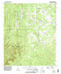
1991 Map of Escabosa
USGS Topo · Published 1996About this map
The Manzanita Mountains define this section of the East Mountains, where Spanish land grants meet federal military and tribal jurisdictions. The map documents the overlap of the Chilili Grant and the Isleta Pueblo Indian Reservation, illustrating a complex landscape of historical tenure. Small settlements like Escabosa and Yrisarri are located along the eastern slopes, while the western portion is dominated by the Kirtland Air Force Base Military Reservation Boundary.
Find a feature on this map
29 named features on this map. Tap any name to fly to it.
Don’t see what you’re looking for? This feature index may not catch every label — zoom into the map to look around manually.
Map Details
Editions of this 1991 Escabosa Map
This is the sole edition of this map. No revisions or reprints were ever made.
Other maps of this area

1892 · San Pedro
USGS Topo · 1:125,000

1917 · Estancia
USGS Topo · 1:125,000

1954 · Bosque Peak
USGS Topo · 1:24,000

1954 · Chilili
USGS Topo · 1:24,000

1954 · Mount Washington
USGS Topo · 1:24,000
1954 · Tijeras
USGS Topo · 1:24,000

1954 · Sedillo
USGS Topo · 1:24,000

1954 · Tajique
USGS Topo · 1:24,000

1954 · Escabosa
USGS Topo · 1:24,000

1954 · Edgewood
USGS Topo · 1:24,000