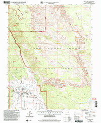
2002 Map of Escalante
USGS Topo · Published 2005About this map
Escalante sits at the nexus of several major protected landscapes in this 2002 revision, serving as a gateway to the high desert plateaus of Southern Utah. The map details the transition from the town’s grid, which includes the High Sch and the Escalante Interagency Visitor Center, into the expansive reaches of the Grand Staircase Escalante National Monument. The Escalante River winds through the eastern portion of the quadrangle, joined by tributaries such as Mamie Creek and Pine Creek. To the north, the terrain rises into the Dixie National Forest and the Box Death Hollow Wilderness, where the Roundy Trail traverses the Black Hills. This survey documents the area just after the turn of the century, showing the established infrastructure of the Escalante Municipal Airport and the scenic All American Road (Highway 12) as it approaches the town from the southeast.
Find a feature on this map
69 named features on this map. Tap any name to fly to it.
Don’t see what you’re looking for? This feature index may not catch every label — zoom into the map to look around manually.
Map Details
Editions of this 2002 Escalante Map
This is the sole edition of this map. No revisions or reprints were ever made.
Other maps of this area

1886 · Escalante
USGS Topo · 1:250,000

1956 · Escalante
USGS Topo · 1:250,000

1960 · Escalante
USGS Topo · 1:250,000

1964 · Tenmile Flat
USGS Topo · 1:24,000

1964 · Dave Canyon
USGS Topo · 1:24,000
1964 · Calf Creek
USGS Topo · 1:24,000

1964 · Canaan Creek
USGS Topo · 1:24,000
1964 · Wide Hollow Reservoir
USGS Topo · 1:24,000
1964 · Roger Peak
USGS Topo · 1:24,000
1964 · Posy Lake
USGS Topo · 1:24,000