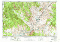
1956 Map of Escalante
USGS Topo · Published 1978About this map
The town of Escalante serves as the primary outpost in this sweeping study of the Colorado Plateau, where the massive Waterpocket Fold and the Kaiparowits Plateau dominate the landscape. This 1950s-era data, updated in 1970, captures the region's geography before the full expansion of Lake Powell was complete. To the south, the Navajo Indian Reservation meets the Colorado River and San Juan River, while isolated outposts like Ticaboo and The Post appear alongside historical remnants such as the Adairville (ruins).
Find a feature on this map
62 named features on this map. Tap any name to fly to it.
Don’t see what you’re looking for? This feature index may not catch every label — zoom into the map to look around manually.
Map Details
Editions of this 1956 Escalante Map
5 editions found

Other maps of this area

1883 · Marsh Pass
USGS Topo · 1:250,000

1885 · San Rafael
USGS Topo · 1:250,000

1885 · La Sal
USGS Topo · 1:250,000

1885 · Beaver
USGS Topo · 1:250,000

1885 · Fish Lake
USGS Topo · 1:250,000

1886 · Kanab
USGS Topo · 1:250,000

1886 · Escalante
USGS Topo · 1:250,000

1886 · Henry Mountains
USGS Topo · 1:250,000

1886 · Abajo
USGS Topo · 1:250,000

1886 · Echo Cliffs
USGS Topo · 1:250,000