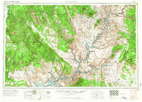
1956 Map of Escalante
USGS Topo · Published 1966About this map
Escalante serves as the primary hub in this mid-century survey of Southern Utah, a period of transition as the Glen Canyon Dam project began to reshape the landscape. The map specifically identifies areas designated to be submerged by the rising waters of Lake Powell, offering a rare look at the original canyons and bars before the reservoir's full expansion. To the south, the Navajo Indian Reservation spans across the Arizona border, centered around the massive Navajo Mountain. This era was also marked by industrial exploration, noted here by Uranium mining activity and the presence of isolated settlements like New Home and Piute Farms. The complex geological features of the Waterpocket Fold and the Straight Cliffs dominate the central terrain, while the eastern portion highlights the deep canyons of the Colorado River and the high peaks of Mount Ellen and Mount Hillers.
Find a feature on this map
95 named features on this map. Tap any name to fly to it.
Don’t see what you’re looking for? This feature index may not catch every label — zoom into the map to look around manually.
Map Details
Editions of this 1956 Escalante Map
5 editions found

Other maps of this area

1883 · Marsh Pass
USGS Topo · 1:250,000

1885 · San Rafael
USGS Topo · 1:250,000

1885 · La Sal
USGS Topo · 1:250,000

1885 · Beaver
USGS Topo · 1:250,000

1885 · Fish Lake
USGS Topo · 1:250,000

1886 · Kanab
USGS Topo · 1:250,000

1886 · Escalante
USGS Topo · 1:250,000

1886 · Henry Mountains
USGS Topo · 1:250,000

1886 · Abajo
USGS Topo · 1:250,000

1886 · Echo Cliffs
USGS Topo · 1:250,000