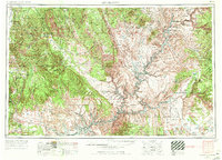
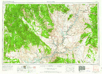
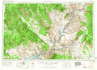
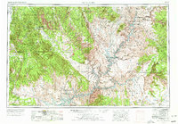
1956 Map of Escalante
USGS Topo · Published 1971About this map
The massive geologic uplift of the Waterpocket Fold and the high elevations of the Kaiparowits Plateau dominate this 1970 revision of the high desert. At this stage of the mid-century, the Colorado River has begun its transformation following the completion of the Glen Canyon Dam, showing the emerging waters of Lake Powell filling the deep canyons. The map tracks the transition from the forested heights of the Dixie National Forest near Escalante and Boulder down to the red rock spires of Monument Valley at the Arizona border. Geologists and surveyors have documented the jagged lines of the Straight Cliffs and the isolation of Navajo Mountain, alongside remote landmarks like Coyote Gulch and the Natural Bridges National Monument, illustrating a landscape defined by its formidable verticality and shifting water levels.
Find a feature on this map
84 named features on this map. Tap any name to fly to it.
Don’t see what you’re looking for? This feature index may not catch every label — zoom into the map to look around manually.
Map Details
Editions of this 1956 Escalante Map
5 editions found

Other maps of this area

1883 · Marsh Pass
USGS Topo · 1:250,000

1885 · San Rafael
USGS Topo · 1:250,000

1885 · La Sal
USGS Topo · 1:250,000

1885 · Beaver
USGS Topo · 1:250,000

1885 · Fish Lake
USGS Topo · 1:250,000

1886 · Kanab
USGS Topo · 1:250,000

1886 · Escalante
USGS Topo · 1:250,000

1886 · Henry Mountains
USGS Topo · 1:250,000

1886 · Abajo
USGS Topo · 1:250,000

1886 · Echo Cliffs
USGS Topo · 1:250,000