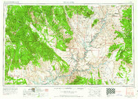
1956 Map of Escalante
USGS Topo · Published 1963About this map
Escalante and the Kaiparowits Plateau dominate this 1950s landscape, surveyed just as the regional geography was being transformed by the creation of Lake Powell. The map documents the intricate drainage systems of the Colorado River and San Juan River before the full impact of the Glen Canyon Dam was realized. Along the western edge, small settlements like Henrieville and Cannonville stand near the Table Cliff Plateau, while the Adairville (ruins) and scattered Uranium prospects hint at the area's pioneer and mining history. The topography is defined by massive structural features like the Waterpocket Fold and the Straight Cliffs, with the Navajo Indian Reservation extending across the southern border. This sheet provides a detailed view of the terrain within Dixie National Forest and the isolated stretches of Glen Canyon during a pivotal era of infrastructure development.
Find a feature on this map
110 named features on this map. Tap any name to fly to it.
Don’t see what you’re looking for? This feature index may not catch every label — zoom into the map to look around manually.
Map Details
Editions of this 1956 Escalante Map
5 editions found

Other maps of this area

1883 · Marsh Pass
USGS Topo · 1:250,000

1885 · San Rafael
USGS Topo · 1:250,000

1885 · La Sal
USGS Topo · 1:250,000

1885 · Beaver
USGS Topo · 1:250,000

1885 · Fish Lake
USGS Topo · 1:250,000

1886 · Kanab
USGS Topo · 1:250,000

1886 · Escalante
USGS Topo · 1:250,000

1886 · Henry Mountains
USGS Topo · 1:250,000

1886 · Abajo
USGS Topo · 1:250,000

1886 · Echo Cliffs
USGS Topo · 1:250,000