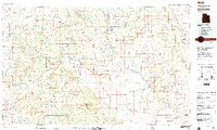
1980 Map of Escalante
USGS Topo · Published 1988About this map
The high desert canyons and tablelands of Southern Utah are captured here during a period of transition in the early 1980s. Centered on Escalante, the landscape is defined by the sharp transition between the Dixie National Forest and the vast sandstone drainage systems of the Escalante River. The map documents early infrastructure like Utah 12 and the Hole-in-the-Rock Road, the latter a critical historical corridor for local settlement. Notable landmarks including the Escalante Petrified Forest State Reserve and Kodachrome Basin State Reserve are shown alongside smaller settlements like Boulder Town and Henrieville. The topographical detail reveals the complex geomorphology of the Kaiparowits Plateau and the sheer face of the Straight Cliffs, marking a rugged intersection of federal and state-managed lands prior to later monument designations.
Find a feature on this map
57 named features on this map. Tap any name to fly to it.
Don’t see what you’re looking for? This feature index may not catch every label — zoom into the map to look around manually.
Map Details
Editions of this 1980 Escalante Map
3 editions found
Other maps of this area

1885 · San Rafael
USGS Topo · 1:250,000

1885 · Beaver
USGS Topo · 1:250,000

1885 · Fish Lake
USGS Topo · 1:250,000

1886 · Kanab
USGS Topo · 1:250,000

1886 · Escalante
USGS Topo · 1:250,000

1886 · Henry Mountains
USGS Topo · 1:250,000

1892 · Henry Mountains
USGS Topo · 1:250,000

1896 · Fish Lake
USGS Topo · 1:250,000

1922 · Upper Last Chance
USGS Topo · 1:63,360

1922 · Rees Canyon
USGS Topo · 1:63,360