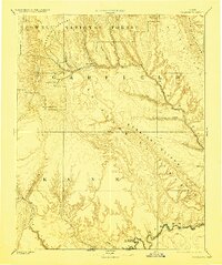
1886 Map of Escalante
USGS Topo · Published 1923About this map
Escalante serves as the primary gateway to the high plateaus and labyrinthine canyonlands of southern Utah in this reconnaissance survey. Situated at the edge of Potato Valley, the settlement is surrounded by massive geological features including the Aquarius Plateau to the north and the towering Straight Cliffs that define the eastern edge of the Kaiparowits Plateau. The map highlights the primitive hydrological network of the Escalante River and Paria River, documenting the terrain before the modern developments of the twentieth century. Along the southern border at the Utah Arizona Boundary Line, the survey marks The Crossing of the Fathers, a site of profound historical importance for early explorers and travelers navigating the Colorado River corridor. The inclusion of the Navajo Indian Res Line and the early boundaries of the Powell National Forest reflects the administrative organization of this remote landscape during the late nineteenth century.
Find a feature on this map
27 named features on this map. Tap any name to fly to it.
Don’t see what you’re looking for? This feature index may not catch every label — zoom into the map to look around manually.
Map Details
Editions of this 1886 Escalante Map
5 editions found
Other maps of this area

1883 · Marsh Pass
USGS Topo · 1:250,000

1885 · San Rafael
USGS Topo · 1:250,000

1885 · Beaver
USGS Topo · 1:250,000

1885 · Fish Lake
USGS Topo · 1:250,000

1886 · Kanab
USGS Topo · 1:250,000

1886 · Escalante
USGS Topo · 1:250,000

1886 · Henry Mountains
USGS Topo · 1:250,000

1886 · Echo Cliffs
USGS Topo · 1:250,000

1886 · Kaibab
USGS Topo · 1:250,000

1891 · Echo Cliffs
USGS Topo · 1:250,000