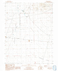
1991 Map of Eskdale
USGS Topo · Published 1991About this map
Eskdale sits at the northern edge of this West Desert landscape, serving as a focal point for settlement amidst the wide expanses of Snake Valley. The geography is defined by the transition from the high elevations of the Conger Range in the northeast to the flat reaches of the Ferguson Desert in the south. Water management is a central theme of this 1991 survey, evidenced by a network of ditches, the Sewage Disposal Pond near the community, and the Buckskin Well (Flowing) out on the flats. This provisional edition documents the infrastructure of the era, including prominent Trans Lines and a Radio Tower that mark the human presence in this otherwise remote portion of Millard County. The proximity of Baker Creek and the Baker road suggest the essential corridors for movement and resources in the Great Basin region.
Find a feature on this map
15 named features on this map. Tap any name to fly to it.
Don’t see what you’re looking for? This feature index may not catch every label — zoom into the map to look around manually.
Map Details
Editions of this 1991 Eskdale Map
This is the sole edition of this map. No revisions or reprints were ever made.
Other maps of this area

1908 · Fish Springs
USGS Topo · 1:250,000

1910 · Fish Springs
USGS Topo · 1:250,000

1949 · Garrison
USGS Topo · 1:62,500

1951 · Garrison
USGS Topo · 1:62,500

1953 · Richfield
USGS Topo · 1:250,000

1953 · Delta
USGS Topo · 1:250,000

1956 · Lund
USGS Topo · 1:250,000

1956 · Ely
USGS Topo · 1:250,000

1958 · Richfield
USGS Topo · 1:250,000

1958 · Delta
USGS Topo · 1:250,000