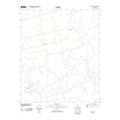
2010 Map of Eskota
USGS Topo · Published 2010About this map
Palava and Tecific anchor this West Texas landscape, where the agricultural grid meets the drainage network of the Brazos River basin. The terrain is defined by a dense system of seasonal watercourses, including the south-flowing Cottonwood Creek and the westward-winding Sweetwater Creek. This 2010 survey highlights the local industrial infrastructure of the Newman Oil Field in the northeast, reflecting the region's long-standing reliance on petroleum extraction. Water management is evidenced by the Headrick Lake Dam and the resulting Headrick Lake in the southwest corner. The map traces an intricate network of county roads, such as Co Rd 130 and Eskota Rd, which connect the scattered homesteads and small settlements across these open plains.
Find a feature on this map
31 named features on this map. Tap any name to fly to it.
Don’t see what you’re looking for? This feature index may not catch every label — zoom into the map to look around manually.
Map Details
Editions of this 2010 Eskota Map
This is the sole edition of this map. No revisions or reprints were ever made.
Other maps of this area

1893 · Roby
USGS Topo · 1:125,000

1893 · Sweetwater
USGS Topo · 1:125,000

1954 · Big Spring
USGS Topo · 1:250,000

1957 · Merkel
USGS Topo · 1:62,500

1957 · Noodle
USGS Topo · 1:62,500

1958 · Big Spring
USGS Topo · 1:250,000

1969 · Busby
USGS Topo · 1:24,000
1969 · Roby
USGS Topo · 1:24,000

1969 · Eskota
USGS Topo · 1:24,000

1969 · Sweetwater
USGS Topo · 1:24,000