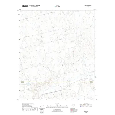
2019 Map of Eskota
USGS Topo · Published 2019About this map
Palava and Eskota sit along the rolling landscape of West Texas, where the border between Fisher and Nolan Counties is defined by the winding course of Sweetwater Cr. This region is characterized by a dense network of intermittent drainage channels, including Horse Hollow and Bitter Cr, which carve through the terrain toward the surrounding creek systems. The map illustrates a strictly rural infrastructure of local county roads, such as Co RD 170 and Eskota RD, which connect these small settlements to the broader agricultural lands of the Panhandle. The intricate network of waterways like Bluff Cr and Cottonwood Cr reveals the natural drainage patterns that have historically dictated the placement of ranches and roads in this semi-arid environment, providing a detailed record of the contemporary landscape as it appeared in the late 2010s.
Find a feature on this map
32 named features on this map. Tap any name to fly to it.
Don’t see what you’re looking for? This feature index may not catch every label — zoom into the map to look around manually.
Map Details
Editions of this 2019 Eskota Map
This is the sole edition of this map. No revisions or reprints were ever made.
Other maps of this area

1893 · Roby
USGS Topo · 1:125,000

1893 · Sweetwater
USGS Topo · 1:125,000

1954 · Big Spring
USGS Topo · 1:250,000

1957 · Merkel
USGS Topo · 1:62,500

1957 · Noodle
USGS Topo · 1:62,500

1958 · Big Spring
USGS Topo · 1:250,000

1969 · Busby
USGS Topo · 1:24,000
1969 · Roby
USGS Topo · 1:24,000

1969 · Eskota
USGS Topo · 1:24,000

1969 · Sweetwater
USGS Topo · 1:24,000