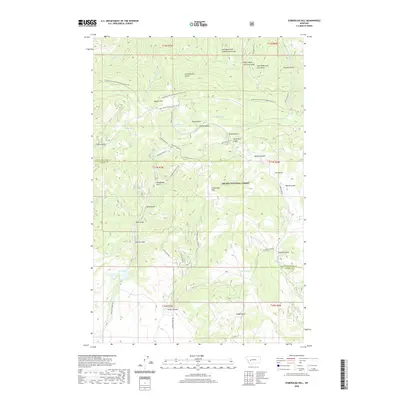
2020 Map of Esmeralda Hill
USGS Topo · Published 2020About this map
Esmeralda Hill and the surrounding drainages of the Helena National Forest define this high-altitude landscape along the border of Lewis and Clark and Powell counties. The Continental Divide National Scenic Trail winds across the northern half of the map, passing landmarks like Meyers Hill and the headwaters of numerous gulches. This area is defined by its deep network of named canyons and gulches, including Clarks Canyon, Sawmill Gulch, and Jerusha Gulch, which feed into larger water systems such as Hope Creek and North Trout Creek. The map provides a detailed view of the backcountry road system used for forest management, such as Snow Shoe Creek Road and Clarks Canyon Road. Historically named water sources like Dana Spring, Polly Spring, and Pauly Springs are scattered throughout the terrain, while Lois Lake sits in the southwestern corner near the confluence of Basin Creek and Spring Creek.
Find a feature on this map
56 named features on this map. Tap any name to fly to it.
Don’t see what you’re looking for? This feature index may not catch every label — zoom into the map to look around manually.
Map Details
Editions of this 2020 Esmeralda Hill Map
This is the sole edition of this map. No revisions or reprints were ever made.
Other maps of this area

1889 · Helena
USGS Topo · 1:250,000

1893 · Helena
USGS Topo · 1:250,000

1899 · Helena
USGS Topo · 1:250,000

1903 · Helena
USGS Topo · 1:250,000

1947 · Butte
USGS Topo · 1:250,000

1958 · Butte
USGS Topo · 1:250,000

1958 · Avon
USGS Topo · 1:62,500

1959 · Elliston
USGS Topo · 1:62,500

1960 · Butte
USGS Topo · 1:250,000

1962 · Butte
USGS Topo · 1:250,000