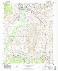
1984 Map of Espanola
USGS Topo · Published 1984About this map
Espanola Valley agriculture and Puebloan heritage define this mid-1980s landscape at the confluence of the Rio Grande and the Santa Cruz River. The map meticulously details the complex irrigation network vital to the high desert, including the Vigil Ditch, La Mesilla Ditch, and Ortiz Ditch, which support traditional farming communities such as Riverside, Santo Niño, and La Mesilla. The proximity of the Santa Clara Indian Reservation and San Ildefonso Indian Reservation highlights the cultural significance of the region, anchored by the Santa Clara Pueblo and San Ildefonso Pueblo. To the west, the prominent landform of Black Mesa rises above the river valley, near the Black Mesa Cem. Transportation history is visible in the Old Railroad Grade running parallel to the river, while the growth of Espanola is marked by modern infrastructure like the Jr High School and various sewage disposal facilities.
Find a feature on this map
66 named features on this map. Tap any name to fly to it.
Don’t see what you’re looking for? This feature index may not catch every label — zoom into the map to look around manually.
Map Details
Editions of this 1984 Espanola Map
2 editions found
Other maps of this area

1889 · Santa Fe
USGS Topo · 1:125,000

1892 · Santa Clara
USGS Topo · 1:125,000

1894 · Santa Fe
USGS Topo · 1:125,000

1918 · Abiquiu
USGS Topo · 1:125,000

1952 · White Rock
USGS Topo · 1:24,000

1952 · Puye
USGS Topo · 1:24,000

1953 · Tesuque
USGS Topo · 1:24,000

1953 · Espanola
USGS Topo · 1:24,000

1953 · Chili
USGS Topo · 1:24,000

1953 · San Juan Pueblo
USGS Topo · 1:24,000