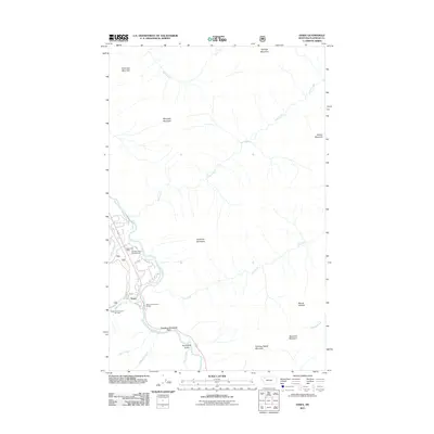
2011 Map of Essex
USGS Topo · Published 2011About this map
Essex sits at a critical junction of transport and topography along the Middle Fork Flathead River. This high-altitude corridor is defined by Theodore Roosevelt Pass, where the drainage of Sheep Creek meets the river valley. The settlement pattern is concentrated around the Essex Post Office and recreational landmarks like the Half-Way Motel Campground and the Essex Cross Country Ski Area. This 2011 survey reveals a landscape dominated by massive peaks, including Scalplock Mountain, Snowslip Mountain, and Mount Shields. The complex network of drainages, such as Park Creek, Ole Creek, and Muir Creek, illustrates the watershed's role in carving the terrain below Salvage Mountain and Riverview Mountain. Local access points like Walton Sportsmans Access highlight the importance of the river for both passage and recreation in Flathead County.
Find a feature on this map
27 named features on this map. Tap any name to fly to it.
Don’t see what you’re looking for? This feature index may not catch every label — zoom into the map to look around manually.
Map Details
Editions of this 2011 Essex Map
This is the sole edition of this map. No revisions or reprints were ever made.
Other maps of this area
1913 · Marias Pass
USGS Topo · 1:125,000
1914 · Nyack
USGS Topo · 1:125,000
1958 · Nimrod
USGS Topo · 1:24,000
1958 · Mount Bradley
USGS Topo · 1:24,000
1958 · Felix Peak
USGS Topo · 1:24,000
1960 · Cut Bank
USGS Topo · 1:250,000
1963 · Cut Bank
USGS Topo · 1:250,000
1964 · Cut Bank
USGS Topo · 1:250,000
1964 · Essex
USGS Topo · 1:24,000
1964 · Pinnacle
USGS Topo · 1:24,000