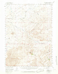
1958 Map of Essex Mountain
USGS Topo · Published 1967About this map
The Emigrant Trail cuts across this high desert landscape of Sweetwater County, marking a historic corridor of western movement through a region defined by complex drainage networks and volcanic landmarks. The terrain is characterized by the prominent rise of Essex Mountain and the distinct formation of Tule Butte, while the Middle Hay Hills and Steamboat Rim provide rugged vertical relief. Water is a critical and concentrated resource in this environment, found at isolated points such as Oz Yoke Springs, Marine Spring, and Hillside Springs. Settlement is sparse, represented by the Middle Hay Ranch and Bar X Ranch, reflecting a landscape dedicated to large-scale ranching. The presence of Pacific Creek and various washes like Alkali Wash illustrate the intermittent nature of water flow in the basin, while industrial activity is noted by a solitary Oil Well and two private airstrips, suggesting the remote logistics of mid-century Wyoming land use.
Find a feature on this map
32 named features on this map. Tap any name to fly to it.
Don’t see what you’re looking for? This feature index may not catch every label — zoom into the map to look around manually.
Map Details
Editions of this 1958 Essex Mountain Map
2 editions found
Other maps of this area

1954 · Rock Springs
USGS Topo · 1:250,000

1955 · Lander
USGS Topo · 1:250,000

1958 · Lander
USGS Topo · 1:250,000

1958 · Rock Springs
USGS Topo · 1:250,000

1958 · Parting of the Ways
USGS Topo · 1:62,500

1958 · Essex Mountain
USGS Topo · 1:62,500

1958 · Boars Tusk
USGS Topo · 1:62,500

1958 · Hay Meadow Reservoir
USGS Topo · 1:24,000

1958 · Tule Butte
USGS Topo · 1:24,000

1958 · Pacific Springs
USGS Topo · 1:24,000