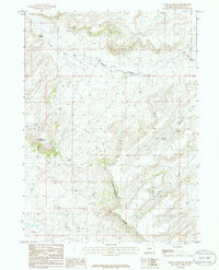
1986 Map of Essex Mountain
USGS Topo · Published 1986About this map
Essex Mountain rises above a high desert landscape characterized by seasonal water sources and distinct geological formations in this 1980s field study. The drainage patterns of Morrow Creek and Jack Creek define the northern territory, while the southern reach is dominated by the prominent Steamboat Rim. This area of Sweetwater County shows a sparse network of unimproved roads and trails, suggesting a land used primarily for ranching or resource access rather than permanent settlement. Strategically located water points such as Marine Springs, Hillside Springs, and Box Spring would have been vital landmarks for anyone navigating the terrain between Indian Gap and the northern Sand Dunes. The map also records Box Canyon and the isolated feature known as La Fonte, providing a record of named landmarks in a vast, open interior.
Find a feature on this map
11 named features on this map. Tap any name to fly to it.
Don’t see what you’re looking for? This feature index may not catch every label — zoom into the map to look around manually.
Map Details
Editions of this 1986 Essex Mountain Map
This is the sole edition of this map. No revisions or reprints were ever made.
Other maps of this area

1954 · Rock Springs
USGS Topo · 1:250,000

1955 · Lander
USGS Topo · 1:250,000

1958 · Lander
USGS Topo · 1:250,000

1958 · Rock Springs
USGS Topo · 1:250,000

1958 · Essex Mountain
USGS Topo · 1:62,500

1958 · Boars Tusk
USGS Topo · 1:62,500

1958 · Tule Butte
USGS Topo · 1:24,000

1958 · Freighter Gap
USGS Topo · 1:62,500

1958 · Superior
USGS Topo · 1:62,500

1961 · Lander
USGS Topo · 1:250,000