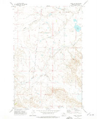
1971 Map of Ester Lake
USGS Topo · Published 1975About this map
The Fort Belknap Indian Reservation Boundary cuts a distinct north-south line through this high-plains landscape, separating reservation lands from the surrounding ranchlands of Phillips County. The terrain is defined by a series of intermittent drainages and coulees, including Sage Hen Coulee and Spring Coulee, which carve through the plateau. Central to the sheet is the eponymous Ester Lake, a localized water feature in an otherwise arid expanse.
Find a feature on this map
8 named features on this map. Tap any name to fly to it.
Don’t see what you’re looking for? This feature index may not catch every label — zoom into the map to look around manually.
Map Details
Editions of this 1971 Ester Lake Map
This is the sole edition of this map. No revisions or reprints were ever made.
Other maps of this area

1953 · Havre
USGS Topo · 1:250,000

1954 · Lewistown
USGS Topo · 1:250,000

1957 · Havre
USGS Topo · 1:250,000

1958 · Havre
USGS Topo · 1:250,000

1959 · Lewistown
USGS Topo · 1:250,000

1965 · Veseth Reservoir
USGS Topo · 1:24,000

1965 · Phillips
USGS Topo · 1:24,000

1965 · Wild Horse Reservoir
USGS Topo · 1:24,000

1971 · Big Flat East
USGS Topo · 1:24,000

1971 · Bear Mountain
USGS Topo · 1:24,000