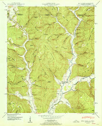
1951 Map of Estill Fork
USGS Topo · Published 1951About this map
Cumberland Mountain and Little Mountain dominate this corner of Alabama and Tennessee, where the valley floor is carved by the converging waters of Larkin Fork and Estill Fork. The rural settlement of Estillfork serves as a central point in this landscape of deep hollows and narrow ridges, such as The Narrows and Hogyard Ridge. The map reveals a highly localized community structure during the late 1940s, with family names and small institutions distributed along the valley corridors. Genealogists will find a wealth of specific landmarks, including the Beech Grove School and Grays Chapel School, alongside numerous burial grounds like Sisk Cem, Reid Cem, and the Old Bostick Hill Cem. These sites, often positioned near churches like Halla Chapel or Freedom Ch, reflect a dispersed but connected mountain society reliant on the surrounding gaps and coves for passage.
Find a feature on this map
120 named features on this map. Tap any name to fly to it.
Don’t see what you’re looking for? This feature index may not catch every label — zoom into the map to look around manually.
Map Details
Editions of this 1951 Estill Fork Map
This is the sole edition of this map. No revisions or reprints were ever made.
Other maps of this area

1888 · Scottsboro
USGS Topo · 1:125,000

1892 · Scottsboro
USGS Topo · 1:125,000

1928 · Decherd
USGS Topo · 1:62,500

1936 · King Cove
USGS Topo · 1:24,000

1936 · Hollytree
USGS Topo · 1:24,000

1936 · Beans Creek
USGS Topo · 1:24,000

1936 · Mud Creek
USGS Topo · 1:24,000

1936 · Hytop
USGS Topo · 1:24,000

1936 · Princeton
USGS Topo · 1:24,000

1936 · Huntland
USGS Topo · 1:24,000