1936 Map of Hytop
USGS Topo · Published 1936About this map
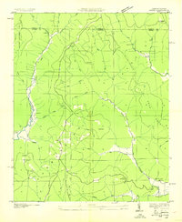
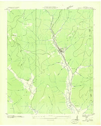
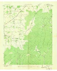
Cumberland Mountain dominates this 1936 survey, which was compiled from aerial photographs by the Tennessee Valley Authority during a transformative era for the region. The high plateau landscape is defined by the settlement of Hytop and the community of Jericho, where narrow trails and family-named hollows like Haney Hollow and Money Hollow snake through the deep relief. The map documents the rural infrastructure of the mid-1930s, including the Walnut Grove Sch and Hytop Cem, alongside numerous springs such as Medlock Spring and McCrary Spring that served as vital water sources.
Find a feature on this map
53 named features on this map. Tap any name to fly to it.
Don’t see what you’re looking for? This feature index may not catch every label — zoom into the map to look around manually.
Map Details
Editions of this 1936 Hytop Map
This is the sole edition of this map. No revisions or reprints were ever made.
Other maps of this area

1886 · Stevenson
USGS Topo · 1:125,000

1888 · Scottsboro
USGS Topo · 1:125,000

1892 · Scottsboro
USGS Topo · 1:125,000

1892 · Stevenson
USGS Topo · 1:125,000

1895 · Stevenson
USGS Topo · 1:125,000

1895 · Sewanee
USGS Topo · 1:125,000

1928 · Decherd
USGS Topo · 1:62,500

1936 · Wannville
USGS Topo · 1:24,000
1936 · Sinking Cove
USGS Topo · 1:24,000
1936 · Beans Creek
USGS Topo · 1:24,000