
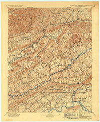
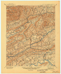
1894 Map of Estillville
USGS Topo · Published 1909About this map
Big Stone Gap serves as a focal point in this late nineteenth-century survey, situated at the convergence of mountain ridges and evolving rail lines. The landscape is defined by the steep relief of Big Black Mountain and Stone Mountain, where natural passages like Natural Tunnel and Benges Gap dictated the paths of early commerce and travel. The network of the South Atlantic and Ohio RR and the Norfolk and Western RR illustrates the era's industrial expansion, linking coal-rich valleys to broader markets.
Find a feature on this map
165 named features on this map. Tap any name to fly to it.
Don’t see what you’re looking for? This feature index may not catch every label — zoom into the map to look around manually.
Map Details
Editions of this 1894 Estillville Map
3 editions found
Other maps of this area

1883 · Morristown
USGS Topo · 1:125,000

1886 · Grundy
USGS Topo · 1:125,000

1887 · Jonesville
USGS Topo · 1:125,000

1890 · Whitesburg
USGS Topo · 1:125,000

1890 · Grundy
USGS Topo · 1:125,000

1891 · Hazard
USGS Topo · 1:125,000

1891 · Roan Mountain
USGS Topo · 1:125,000

1891 · Jonesville
USGS Topo · 1:125,000

1892 · Grundy
USGS Topo · 1:125,000

1892 · Greeneville
USGS Topo · 1:125,000