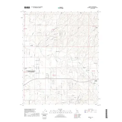
2018 Map of Estrella
USGS Topo · Published 2018About this map
The Estrella River drainage carves a complex network of canyons and ridges through this Central Coast landscape, defining the rural character of northern San Luis Obispo County. Agricultural land and viticulture roads such as Chardonnay Pl and Cabernet Pl sit alongside the established community of Whitley Gardens and the smaller settlement of Estrella. Aviation history is well-represented here, with the Paso Robles Municipal Airport occupying the western edge and the private Bonel Airport situated to the east. Transportation through the area relies on the Fifteenmile Bridge and a grid of rural routes including Estrella Rd and Ranchita Canyon Rd. The terrain is marked by distinctive local landmarks like Enchanted Hill and numerous deep draws such as Hog Canyon, Keyes Canyon, and Wild Horse Canyon.
Find a feature on this map
105 named features on this map. Tap any name to fly to it.
Don’t see what you’re looking for? This feature index may not catch every label — zoom into the map to look around manually.
Map Details
Editions of this 2018 Estrella Map
This is the sole edition of this map. No revisions or reprints were ever made.
Other maps of this area

1914 · Cholame
USGS Topo · 1:125,000

1915 · Cholame
USGS Topo · 1:125,000

1917 · Cholame
USGS Topo · 1:125,000

1919 · San Miguel
USGS Topo · 1:62,500

1919 · Paso Robles
USGS Topo · 1:62,500

1943 · Shandon
USGS Topo · 1:31,680

1943 · Paso Robles
USGS Topo · 1:62,500

1943 · Shedd Canyon
USGS Topo · 1:31,680
1943 · Cholame Hills
USGS Topo · 1:31,680

1947 · San Luis Obispo
USGS Topo · 1:250,000