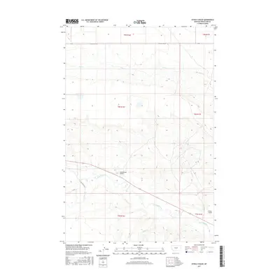
2017 Map of Ethels Coulee
USGS Topo · Published 2017About this map
The Musselshell River meanders across this rural section of Montana, defining the lower portion of the landscape. The river valley is flanked by several significant coulees, most notably Ethels Coulee and Cottonwood Coulee, which serve as natural drainage features through the prairie terrain. The map reflects a region dominated by ranching and agriculture, where local transit is facilitated by routes such as Miller Ranch Ln and Lower Nihill Rd. This 2017 survey details a landscape where water remains the primary influencer of local activity, with Alkali Cr and Timber Cr cutting through the open ranges and sections of the Public Land Survey System. The presence of named ranch access roads highlights the dispersed but enduring human presence in this area of Wheatland County.
Find a feature on this map
49 named features on this map. Tap any name to fly to it.
Don’t see what you’re looking for? This feature index may not catch every label — zoom into the map to look around manually.
Map Details
Editions of this 2017 Ethels Coulee Map
This is the sole edition of this map. No revisions or reprints were ever made.
Other maps of this area

1889 · Big Snowy Mountain
USGS Topo · 1:250,000

1893 · Big Snowy Mountain
USGS Topo · 1:250,000

1954 · Roundup
USGS Topo · 1:250,000

1958 · Roundup
USGS Topo · 1:250,000
1986 · Oka
USGS Topo · 1:24,000
1986 · Ten O'Clock Gate
USGS Topo · 1:24,000

1986 · Shawmut
USGS Topo · 1:24,000
1986 · Devils Pocket
USGS Topo · 1:24,000
1986 · Oxford
USGS Topo · 1:24,000
1986 · Harlowton
USGS Topo · 1:24,000