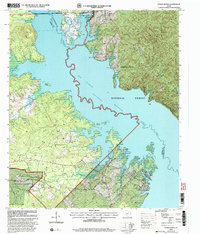
2003 Map of Etoile South
USGS Topo · Published 2004About this map
The Sam Rayburn Reservoir dominates this East Texas landscape, following the winding course of the Angelina River along the border of Nacogdoches and Angelina counties. Published just after the turn of the millennium, the map shows the reservoir at its normal pool elevation of 164 feet, creating a jagged shoreline of inlets and points. Much of the land is protected within the Angelina National Forest, where a network of forest roads like Fay Jones Road and Eugene Walker Road provide access to the timberlands.
Find a feature on this map
41 named features on this map. Tap any name to fly to it.
Don’t see what you’re looking for? This feature index may not catch every label — zoom into the map to look around manually.
Map Details
Editions of this 2003 Etoile South Map
This is the sole edition of this map. No revisions or reprints were ever made.
Other maps of this area

1931 · Zavalla
USGS Topo · 1:62,500

1932 · Manning
USGS Topo · 1:62,500

1949 · Lufkin
USGS Topo · 1:62,500

1949 · Platt
USGS Topo · 1:24,000

1949 · Huntington
USGS Topo · 1:24,000

1950 · Platt
USGS Topo · 1:24,000

1950 · Huntington
USGS Topo · 1:24,000

1953 · Palestine
USGS Topo · 1:250,000

1957 · Palestine
USGS Topo · 1:250,000

1958 · Zavalla
USGS Topo · 1:62,500