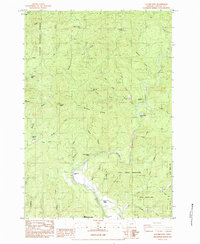
1984 Map of Euchre Mtn
USGS Topo · Published 1984About this map
The Siletz River winds through the heart of the Siletz Indian Reservation in the mid-1980s, revealing a landscape defined by timber history and tribal lands. This survey documents several historical locations no longer in active use, including Werner Camp, Peck Cabin, and Gorge Camp, which point to the era's logging and forestry operations. To the west, the Siuslaw National Forest encompasses the high points of Euchre Mtn and Little Euchre Mtn, while Euchre Falls marks the descent of Euchre Creek. Along the riverbanks, recreational and agricultural spots like Moonshine Park and the Upper Farm indicate how the local community utilized the narrow valley floors. The complex drainage network, featuring Wildcat Creek and Mill Creek, underscores the difficult terrain of Wildcat Ridge and Gobblers Knobb.
Find a feature on this map
42 named features on this map. Tap any name to fly to it.
Don’t see what you’re looking for? This feature index may not catch every label — zoom into the map to look around manually.
Map Details
Editions of this 1984 Euchre Mtn Map
This is the sole edition of this map. No revisions or reprints were ever made.
Other maps of this area

1939 · Marys Peak
USGS Topo · 1:62,500

1942 · Euchre Mtn
USGS Topo · 1:62,500

1942 · Marys Peak
USGS Topo · 1:62,500

1942 · Valsetz
USGS Topo · 1:62,500

1942 · Toledo
USGS Topo · 1:62,500

1943 · Euchre Mtn
USGS Topo · 1:62,500

1953 · Salem
USGS Topo · 1:250,000

1954 · Salem
USGS Topo · 1:250,000

1956 · Valsetz
USGS Topo · 1:62,500

1957 · Marys Peak
USGS Topo · 1:62,500