
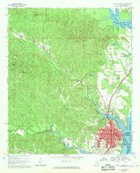
1968 Map of Eufaula North
USGS Topo · Published 1970About this map
Eufaula serves as the focal point of this late-1960s survey, situated along the western banks of the Walter F George Reservoir on the Alabama-Georgia border. The city’s developed street grid includes numerous civic landmarks like the US Coast Guard Station, McCoo High Sch, and the Chewalla Marina, reflecting a river-oriented economy bolstered by the Chattahoochee River. Beyond the city limits, the Central of Georgia railroad cuts through the terrain toward smaller settlements like Lugo and Hoboken. The northeastern quadrant is dominated by the Cowikee National Wildlife Refuge, where the South Fork Cowikee Creek and North Fork Cowikee Creek merge into the reservoir. This map is particularly useful for genealogical research, documenting several small churches and family-named cemeteries such as Bascom Cem and Weedon Cem scattered across the rural landscape.
Find a feature on this map
52 named features on this map. Tap any name to fly to it.
Don’t see what you’re looking for? This feature index may not catch every label — zoom into the map to look around manually.
Map Details
Editions of this 1968 Eufaula North Map
2 editions found
Other maps of this area

1953 · Dothan
USGS Topo · 1:250,000

1954 · Dothan
USGS Topo · 1:250,000

1955 · Dothan
USGS Topo · 1:250,000

1955 · Phenix City
USGS Topo · 1:250,000

1957 · Phenix City
USGS Topo · 1:250,000

1958 · Phenix City
USGS Topo · 1:250,000

1967 · Hatcher
USGS Topo · 1:24,000

1967 · Georgetown
USGS Topo · 1:24,000

1968 · Baker Hill
USGS Topo · 1:24,000

1968 · White Oak
USGS Topo · 1:24,000