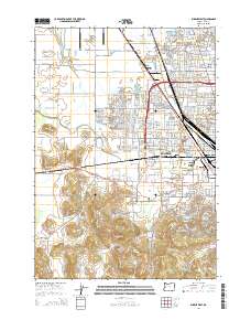
2014 Map of Eugene West
USGS Topo · Published 2014About this map
The western suburbs and industrial fringes of Eugene are defined here by a transition from dense residential neighborhoods like Bethel and River Road to the open agricultural and aviation lands of the southern Willamette Valley. The northern extent of the map is anchored by the Mahlon Sweet Field Airport, while the Southern Pacific rail line cuts through the northeast corner near Irving. The landscape south of the urbanized areas of Danebo becomes increasingly vertical, rising into the foothills of the Coast Range. These uplands are marked by distinctive peaks such as Murray Hill, Bailey Hill, and Cantrell Hill, providing a stark contrast to the flat, hydrological-engineered valley floor where the Amazon Creek Diversion Channel directs water away from the city center. Historical landmarks, including the Oak Hill Cem and the campus of the Eugene Bible Coll, offer specific points of interest for local researchers.
Find a feature on this map
309 named features on this map. Tap any name to fly to it.
Don’t see what you’re looking for? This feature index may not catch every label — zoom into the map to look around manually.
Map Details
Editions of this 2014 Eugene West Map
This is the sole edition of this map. No revisions or reprints were ever made.
Other maps of this area

1909 · Elmira
USGS Topo · 1:62,500

1910 · Eugene
USGS Topo · 1:62,500

1921 · Cottage Grove
USGS Topo · 1:62,500

1922 · Elmira
USGS Topo · 1:62,500

1940 · Eugene
USGS Topo · 1:62,500

1942 · Elmira
USGS Topo · 1:62,500

1942 · Crow
USGS Topo · 1:62,500

1945 · Crow
USGS Topo · 1:62,500

1946 · Eugene
USGS Topo · 1:62,500

1949 · Eugene
USGS Topo · 1:62,500