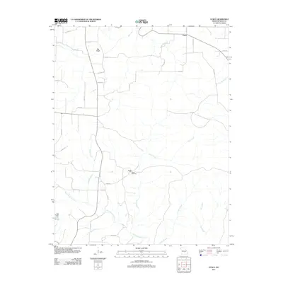
2011 Map of Eunice
USGS Topo · Published 2011About this map
Nagle Post Office anchors the small settlement of Nagle in this early 21st-century study of Texas County. The landscape is defined by a dense network of watercourses, where the North Prong Jacks Fork and its many tributaries, such as Saddle Branch, Sanders Branch, and Black Branch, drain the territory. To the north, the community of Eunice and the eponymous Big Creek settlement sit along a rural road system that includes family-named routes like Boster Rd and Scenic Rd. The mapping of Lake Gemay and its Lake Gemay Dam in the southwest corner illustrates local water management and land use within the Ozark region. This survey highlights the persistence of small post-office-centric communities and the intricate drainage patterns of the Peters Creek and Dry Bone Creek basins.
Find a feature on this map
38 named features on this map. Tap any name to fly to it.
Don’t see what you’re looking for? This feature index may not catch every label — zoom into the map to look around manually.
Map Details
Editions of this 2011 Eunice Map
This is the sole edition of this map. No revisions or reprints were ever made.
Other maps of this area

1932 · Cedar Grove
USGS Topo · 1:48,000

1945 · Clear Springs
USGS Topo · 1:62,500

1946 · Summersville
USGS Topo · 1:62,500

1948 · Clear Springs
USGS Topo · 1:62,500

1948 · Summersville
USGS Topo · 1:62,500

1949 · Rolla
USGS Topo · 1:250,000

1951 · Raymondville
USGS Topo · 1:24,000

1951 · Houston
USGS Topo · 1:24,000
1951 · Hartshorn
USGS Topo · 1:24,000

1951 · Raymondville
USGS Topo · 1:62,500