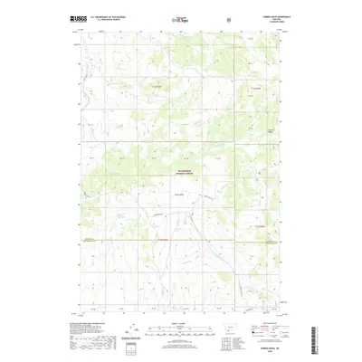
2020 Map of Eureka Basin
USGS Topo · Published 2020About this map
Beaverhead National Forest defines this high-elevation landscape where the Gravelly Range straddles the border of Madison and Beaverhead counties. This 2020 topographic survey traces a vital watershed divide in Southwest Montana, where headwater streams like the Ruby River flow westward while the West Fork Madison River drains to the east. The terrain is characterized by the Eureka Basin, a central geographic feature accessed by the winding Eureka Basin Rd. Water sources are critical in this alpine environment, noted by Long Creek Spring Number One, Lone Willow Spring, and Twin Springs. For researchers and outdoorsmen, the map identifies specific landmarks like Fish Creek Lake and the high-altitude route of the Gravelly Range Rd, documenting the contemporary management and natural geography of these public lands.
Find a feature on this map
28 named features on this map. Tap any name to fly to it.
Don’t see what you’re looking for? This feature index may not catch every label — zoom into the map to look around manually.
Map Details
Editions of this 2020 Eureka Basin Map
This is the sole edition of this map. No revisions or reprints were ever made.
Other maps of this area

1950 · Lower Red Rock Lake
USGS Topo · 1:62,500

1950 · Monument Ridge
USGS Topo · 1:62,500

1955 · Dubois
USGS Topo · 1:250,000

1955 · Ashton
USGS Topo · 1:250,000

1958 · Dubois
USGS Topo · 1:250,000

1958 · Ashton
USGS Topo · 1:250,000

1960 · Ashton
USGS Topo · 1:250,000

1968 · Stonehouse Mountain
USGS Topo · 1:24,000

1968 · Antelope Peak
USGS Topo · 1:24,000
1968 · Spur Mountain
USGS Topo · 1:24,000