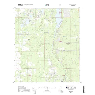
2021 Map of Eureka Dam
USGS Topo · Published 2021About this map
The Ocklawaha River winds through the heart of the North Florida wilderness, defining the boundary between the dense pine and cypress stands of the Ocala National Forest and the lake-dotted interior of Marion County. This 2021 survey details the settlement of Eureka near the Eureka Dam, a significant landmark in the regional hydrology. To the west, a network of residential roads like NE 230th St and NE 227th St service the communities surrounding Horseshoe Lake, Island Lake, and Deer Back Lake. Local history is anchored by the Cornelius Memorial Cem and the small settlement at Bay Lake. The landscape is a complex mosaic of wetlands and small water bodies, including Waldron Millpond and Bully Lake, illustrating the traditional Floridian pattern of high-ground settlement amidst a seasonally shifting aquatic environment.
Find a feature on this map
65 named features on this map. Tap any name to fly to it.
Don’t see what you’re looking for? This feature index may not catch every label — zoom into the map to look around manually.
Map Details
Editions of this 2021 Eureka Dam Map
This is the sole edition of this map. No revisions or reprints were ever made.
Other maps of this area

1893 · Citra
USGS Topo · 1:62,500

1895 · Citra
USGS Topo · 1:62,500

1915 · Interlachen
USGS Topo · 1:48,000

1916 · Interlachen
USGS Topo · 1:62,500

1938 · Hawthorn
USGS Topo · 1:48,000

1943 · Hawthorn
USGS Topo · 1:62,500

1944 · Interlachen
USGS Topo · 1:62,500

1949 · Keuka
USGS Topo · 1:24,000

1949 · Rodman
USGS Topo · 1:24,000

1949 · Interlachen
USGS Topo · 1:62,500