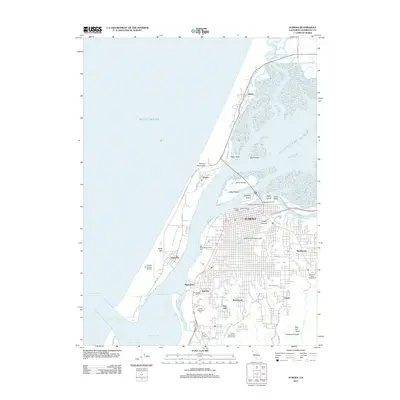
2012 Map of Eureka
USGS Topo · Published 2012About this map
Humboldt Bay dominates this coastal landscape, where the city of Eureka serves as a central hub for maritime and recreational activity. The map reveals the intricate network of channels and sloughs that define the region's geography, including the Entrance Channel and the Mad River Slough. On the protective Samoa Peninsula, the small settlements of Samoa and Fairhaven sit across the water from the urban core, connected by the Samoa Bridge which spans Indian Island. Residential developments such as Myrtletown, Cutten, and Rosewood spread eastward into the foothills, while the coastline is marked by infrastructure like the Del Norte Street Fishing Pier and the Eureka Boat Basin. This 2012 survey illustrates the modern layout of Humboldt County’s largest city, documenting established local institutions like Sunset Memorial Park and the Redwood Acres Fairground.
Find a feature on this map
70 named features on this map. Tap any name to fly to it.
Don’t see what you’re looking for? This feature index may not catch every label — zoom into the map to look around manually.
Map Details
Editions of this 2012 Eureka Map
This is the sole edition of this map. No revisions or reprints were ever made.
Other maps of this area

1916 · Cape Fortunas
USGS Topo · 1:62,500

1922 · Eureka
USGS Topo · 1:62,500

1933 · Eureka
USGS Topo · 1:48,000

1942 · Eureka
USGS Topo · 1:62,500

1943 · Ferndale
USGS Topo · 1:62,500

1944 · Fortuna
USGS Topo · 1:62,500

1949 · Eureka
USGS Topo · 1:250,000

1951 · Eureka
USGS Topo · 1:62,500

1951 · Ferndale
USGS Topo · 1:62,500
1952 · Arcata North
USGS Topo · 1:24,000