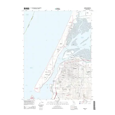
2015 Map of Eureka
USGS Topo · Published 2015About this map
The coastal city of Eureka is centered on this 2015 survey, revealing the complex maritime geography of Arcata Bay and the narrow Samoa Peninsula. The land is defined by its relationship with the water, from the industrial and residential pockets of Samoa and Fairhaven on the North Spit to the navigational channels of the Inner Reach and Outer Reach. Inland, the city's growth is marked by established neighborhoods like Myrtletown and Cutten, alongside significant memorial sites such as Myrtle Grove Memorial Cemetery and Sunset Memorial Park. The southern portion of the map transitions into the riparian landscapes of the Elk River and Swain Slough, where tidal influences meet the coastal lowlands. This survey provides a contemporary look at the infrastructure of the North Coast, including the vital link of the Samoa Bridge connecting the mainland to Indian Island and the peninsula beyond.
Find a feature on this map
83 named features on this map. Tap any name to fly to it.
Don’t see what you’re looking for? This feature index may not catch every label — zoom into the map to look around manually.
Map Details
Editions of this 2015 Eureka Map
This is the sole edition of this map. No revisions or reprints were ever made.
Other maps of this area

1916 · Cape Fortunas
USGS Topo · 1:62,500

1922 · Eureka
USGS Topo · 1:62,500

1933 · Eureka
USGS Topo · 1:48,000

1942 · Eureka
USGS Topo · 1:62,500

1943 · Ferndale
USGS Topo · 1:62,500

1944 · Fortuna
USGS Topo · 1:62,500

1949 · Eureka
USGS Topo · 1:250,000

1951 · Eureka
USGS Topo · 1:62,500

1951 · Ferndale
USGS Topo · 1:62,500
1952 · Arcata North
USGS Topo · 1:24,000