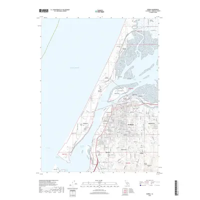
2018 Map of Eureka
USGS Topo · Published 2018About this map
The complex shoreline of Humboldt Bay is the centerpiece of this 2018 survey, where the city of Eureka serves as the regional hub for transportation and commerce. A series of intricate channels, including the Entrance Channel and North Bay Channel, separate the mainland from the Samoa Peninsula, where the settlements of Samoa and Fairhaven are connected by the Samoa Bridge. The urban layout shows the residential growth of neighborhoods like Myrtletown, Rosewood, and Cutten as they expand into the hillsides east of the bay.
Find a feature on this map
103 named features on this map. Tap any name to fly to it.
Don’t see what you’re looking for? This feature index may not catch every label — zoom into the map to look around manually.
Map Details
Editions of this 2018 Eureka Map
This is the sole edition of this map. No revisions or reprints were ever made.
Other maps of this area

1916 · Cape Fortunas
USGS Topo · 1:62,500

1922 · Eureka
USGS Topo · 1:62,500

1933 · Eureka
USGS Topo · 1:48,000

1942 · Eureka
USGS Topo · 1:62,500

1943 · Ferndale
USGS Topo · 1:62,500

1944 · Fortuna
USGS Topo · 1:62,500

1949 · Eureka
USGS Topo · 1:250,000

1951 · Eureka
USGS Topo · 1:62,500

1951 · Ferndale
USGS Topo · 1:62,500
1952 · Arcata North
USGS Topo · 1:24,000