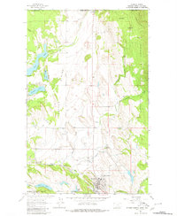
1963 Map of Eureka North
USGS Topo · Published 1980About this map
The Tobacco Plains of Lincoln County, Montana, define the landscape of this 1963 survey, where the international border meets the Kootenai National Forest. The map documents the border crossing at Roosville, marked by US Customs and the Roosville Sch, just south of the Canadian line. Further south, the settlement of Eureka serves as a local hub, situated along the Burlington Northern railroad and the Tobacco River. The layout of the region reveals a reliance on water and rail, with several small lakes like Sophie Lake and Tetrault Lake dotting the plains near the tracks. Significant local history is captured through the locations of the Eureka Cem and the Iowa Flats Sch, providing a detailed view of the community's rural infrastructure before modern expansions. The terrain is a mix of flat plains and rising peaks, anchored by Ksanka Peak to the east.
Find a feature on this map
37 named features on this map. Tap any name to fly to it.
Don’t see what you’re looking for? This feature index may not catch every label — zoom into the map to look around manually.
Map Details
Editions of this 1963 Eureka North Map
3 editions found
Other maps of this area

1913 · Stryker
USGS Topo · 1:125,000

1916 · Stryker
USGS Topo · 1:125,000

1957 · Kalispell
USGS Topo · 1:250,000

1960 · Kalispell
USGS Topo · 1:250,000

1961 · Kalispell
USGS Topo · 1:250,000

1963 · Rexford
USGS Topo · 1:24,000

1963 · Eureka North
USGS Topo · 1:24,000

1963 · Ksanka Peak
USGS Topo · 1:24,000

1963 · Eureka South
USGS Topo · 1:24,000
1963 · Fortine
USGS Topo · 1:24,000