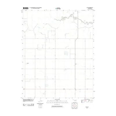
2010 Map of Eva
USGS Topo · Published 2010About this map
Goff Creek meanders across the northern reaches of this High Plains landscape, providing a rare natural break in the strictly gridded agricultural section lines that define Texas County. The settlement of Eva and the community at Four Corners serve as primary anchors for the local road network, which is meticulously organized into a series of numbered and lettered routes. To the west, the label for Doolin marks another point of historical interest in this rural expanse. The map illustrates a high degree of land management, where roads like Mile 5 Rd and Road N create a precise geometric framework for the surrounding farms and ranches. This 2010 survey emphasizes the enduring reliance on these section-line roads to connect the isolated homesteads and small settlements scattered throughout the Oklahoma Panhandle.
Find a feature on this map
20 named features on this map. Tap any name to fly to it.
Don’t see what you’re looking for? This feature index may not catch every label — zoom into the map to look around manually.
Map Details
Editions of this 2010 Eva Map
This is the sole edition of this map. No revisions or reprints were ever made.
Other maps of this area

1954 · Perryton
USGS Topo · 1:250,000

1954 · Dalhart
USGS Topo · 1:250,000

1958 · Perryton
USGS Topo · 1:250,000

1958 · Dalhart
USGS Topo · 1:250,000

1962 · Dalhart
USGS Topo · 1:250,000

1971 · Griggs NE
USGS Topo · 1:24,000

1971 · Sturgis
USGS Topo · 1:24,000

1971 · Hopkins
USGS Topo · 1:24,000

1973 · Texhoma NE
USGS Topo · 1:24,000
1973 · Elkhart South
USGS Topo · 1:24,000