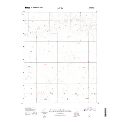
2018 Map of Eva
USGS Topo · Published 2018About this map
The settlement of Eva and the surrounding agricultural landscape of Texas County are defined by a strict section-line grid typical of the High Plains. This 2018 survey reveals the persistent structure of the Public Land Survey System, where modern county roads like N0570 Rd and N0580 Rd trace the paths of historical homesteading boundaries. The terrain is largely dominated by these rectilinear developments, interrupted only by the natural, winding course of Goff Cr in the northern portion of the quadrangle. Aside from the established community at Eva, the map identifies the location of Doolin, a smaller geographic point that provides a reference for local family history and rural development patterns in the Oklahoma Panhandle. This area remains a study in the intersection of natural drainage systems and the rigid human geometry imposed on the land for ranching and farming.
Find a feature on this map
35 named features on this map. Tap any name to fly to it.
Don’t see what you’re looking for? This feature index may not catch every label — zoom into the map to look around manually.
Map Details
Editions of this 2018 Eva Map
This is the sole edition of this map. No revisions or reprints were ever made.
Other maps of this area

1954 · Perryton
USGS Topo · 1:250,000

1954 · Dalhart
USGS Topo · 1:250,000

1958 · Perryton
USGS Topo · 1:250,000

1958 · Dalhart
USGS Topo · 1:250,000

1962 · Dalhart
USGS Topo · 1:250,000

1971 · Griggs NE
USGS Topo · 1:24,000

1971 · Sturgis
USGS Topo · 1:24,000

1971 · Hopkins
USGS Topo · 1:24,000

1973 · Texhoma NE
USGS Topo · 1:24,000
1973 · Elkhart South
USGS Topo · 1:24,000