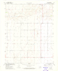
1973 Map of Eva
USGS Topo · Published 1975About this map
Goff Creek meanders through the high plains of the Oklahoma Panhandle, cutting through the distinctive topography of Carthage and Turney. This 1970s landscape is defined by its energy infrastructure, marked by an extensive Oil and Gas Field and a network of wells and a Pipeline that crisscross the region. The map captures the small community of Eva and the nearby Four Corners, centers of local life alongside the Yarbrough Sch. An Old Railroad Grade provides a physical record of former transportation routes that once linked these remote settlements. Beyond the energy and agriculture sectors, smaller industrial footprints like the Caliche Pit and the Sewage Disposal Pond reflect the practicalities of rural development during this era. The detailed mapping of fence and field lines offers a granular look at the land ownership and agricultural boundaries of Texas County at the time.
Find a feature on this map
14 named features on this map. Tap any name to fly to it.
Don’t see what you’re looking for? This feature index may not catch every label — zoom into the map to look around manually.
Map Details
Editions of this 1973 Eva Map
This is the sole edition of this map. No revisions or reprints were ever made.
Other maps of this area

1954 · Perryton
USGS Topo · 1:250,000

1954 · Dalhart
USGS Topo · 1:250,000

1958 · Perryton
USGS Topo · 1:250,000

1958 · Dalhart
USGS Topo · 1:250,000

1962 · Dalhart
USGS Topo · 1:250,000

1971 · Griggs NE
USGS Topo · 1:24,000

1971 · Sturgis
USGS Topo · 1:24,000

1971 · Hopkins
USGS Topo · 1:24,000

1973 · Texhoma NE
USGS Topo · 1:24,000
1973 · Elkhart South
USGS Topo · 1:24,000