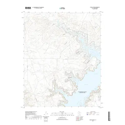
2019 Map of Evans Canyon
USGS Topo · Published 2019About this map
Lake Meredith dominates the eastern landscape of this Moore County region, where the Canadian River flows through the heart of the Lake Meredith National Recreation Area. The terrain is defined by a complex network of drainage systems, including Evans Canyon and Martins Canyon, which carve through the high plains toward the reservoir. These canyons and their associated breaks, such as Chimney Hollow and Timber Hollow, represent the significant topographic relief typical of the Texas Panhandle's river breaks. For genealogists and local historians, the presence of Record Cem in the northeast provides a specific point of interest. The map also documents the local transportation network, featuring Blue West Rd and FM 1913, which provide access to shoreline features like Harbor Bay.
Find a feature on this map
22 named features on this map. Tap any name to fly to it.
Don’t see what you’re looking for? This feature index may not catch every label — zoom into the map to look around manually.
Map Details
Editions of this 2019 Evans Canyon Map
This is the sole edition of this map. No revisions or reprints were ever made.
Other maps of this area

1936 · Fourways
USGS Topo · 1:62,500

1939 · Sanford
USGS Topo · 1:62,500

1953 · Sanford
USGS Topo · 1:24,000

1953 · Alibates Ranch
USGS Topo · 1:24,000

1953 · Evans Canyon
USGS Topo · 1:24,000

1953 · Deal
USGS Topo · 1:24,000

1953 · McDowell Creek
USGS Topo · 1:24,000

1953 · Spencer Draw
USGS Topo · 1:24,000

1954 · Amarillo
USGS Topo · 1:250,000

1958 · Amarillo
USGS Topo · 1:250,000