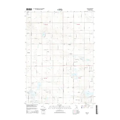
2014 Map of Evans
USGS Topo · Published 2014About this map
Wabasis Lake and a dense network of glacial kettle lakes define this pocket of Kent County, where rural settlements like Harvard and Evans anchor the landscape. The region is characterized by small, concentrated communities and numerous family burial grounds, including the White Swan Cem and Saint Margaret's Catholic Cem, which reflect the area's pioneer and immigrant lineage. The mapping captures a transition in land use, where traditional agricultural plots are interspersed with recreational aviation at the Wabasis Lake Airport and residential developments near Scram Lake and Little Myers Lake. Throughout the township, numerous drainages such as Beaver Dam Cr and Coopers Cr flow through the undulating terrain of the Cheney Hills, connecting the many smaller water bodies like Angel Lake and Stoner Lake that have long shaped local land boundaries and settlement patterns.
Find a feature on this map
100 named features on this map. Tap any name to fly to it.
Don’t see what you’re looking for? This feature index may not catch every label — zoom into the map to look around manually.
Map Details
Editions of this 2014 Evans Map
This is the sole edition of this map. No revisions or reprints were ever made.
Other maps of this area

1918 · Cedar Springs
USGS Topo · 1:62,500

1943 · Cedar Springs
USGS Topo · 1:62,500

1954 · Midland
USGS Topo · 1:250,000

1958 · Midland
USGS Topo · 1:250,000

1958 · Sand Lake
USGS Topo · 1:62,500

1959 · Midland
USGS Topo · 1:250,000

1959 · Howard City
USGS Topo · 1:62,500

1966 · Midland
USGS Topo · 1:250,000

1967 · Cedar Springs
USGS Topo · 1:24,000
1967 · Rockford
USGS Topo · 1:24,000