
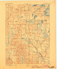
1894 Map of Evansville
USGS Topo · Published 1894About this map
Evansville and Oregon anchor this late-nineteenth-century survey of the southern Wisconsin prairie and glacial lake country. The landscape is defined by its transition from the rolling uplands of Fitchburg and Dunn townships down toward the Sugar River and Allen Creek drainage. At this time, the region's economy was tightly bound to the expansion of the Chicago and North Western Railroad and the Illinois Central R.R. (Freeport Div.), which facilitated the growth of shipping points like Brooklyn and Union. Small crossroads settlements such as Oak Hall and Lakeview appear alongside significant water bodies like Lake Kegonsa and Lake Waubesa. The map documents a precisely surveyed agricultural network, showing the placement of farmsteads and the early infrastructure that connected Dane, Rock, and Green counties before the modern highway system reshaped these rural communities.
Find a feature on this map
43 named features on this map. Tap any name to fly to it.
Don’t see what you’re looking for? This feature index may not catch every label — zoom into the map to look around manually.
Map Details
Editions of this 1894 Evansville Map
2 editions found
Other maps of this area

1889 · Evansville
USGS Topo · 1:62,500

1890 · Madison
USGS Topo · 1:62,500

1890 · Sun Prairie
USGS Topo · 1:62,500

1890 · Stoughton
USGS Topo · 1:62,500

1891 · Janesville
USGS Topo · 1:62,500

1892 · Madison
USGS Topo · 1:62,500

1893 · Janesville
USGS Topo · 1:62,500

1893 · Brodhead
USGS Topo · 1:62,500

1896 · Sun Prairie
USGS Topo · 1:62,500

1904 · Madison
USGS Topo · 1:62,500