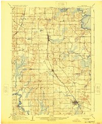
1906 Map of Evansville
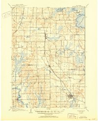
USGS Topo · Published 1925About this map
Evansville serves as a primary rail hub on this southern Wisconsin landscape, where the Chicago and Northwestern and other C. & N. W. R. R. lines converge to connect the agricultural hinterlands. The terrain is defined by its glacial history, featuring the prominent Lake Waubesa and Lake Kegonsa in the north, alongside numerous smaller kettle lakes like Lake Barney and Lake Harriet. Submerged contours provided by the Wisconsin Geological and Natural History Survey offer rare bathymetric detail for these water bodies during the early twentieth century. Small rural settlements and crossroad hamlets such as Brooklyn, Oregon, and Rutland dot the prairie, while the Illinois Central railroad cuts through the western sections near Attica. The intersection of drainage systems, including Badfish Creek and Allen Creek, illustrates the complex hydrology that influenced the placement of early townships and transportation routes across Rock, Dane, and Green counties.
Find a feature on this map
40 named features on this map. Tap any name to fly to it.
Don’t see what you’re looking for? This feature index may not catch every label — zoom into the map to look around manually.
Map Details
Editions of this 1906 Evansville Map
3 editions found

Other maps of this area

1889 · Evansville
USGS Topo · 1:62,500

1890 · Madison
USGS Topo · 1:62,500

1890 · Sun Prairie
USGS Topo · 1:62,500

1890 · Stoughton
USGS Topo · 1:62,500

1891 · Janesville
USGS Topo · 1:62,500

1892 · Madison
USGS Topo · 1:62,500

1893 · Janesville
USGS Topo · 1:62,500

1893 · Brodhead
USGS Topo · 1:62,500

1894 · Evansville
USGS Topo · 1:62,500

1896 · Sun Prairie
USGS Topo · 1:62,500