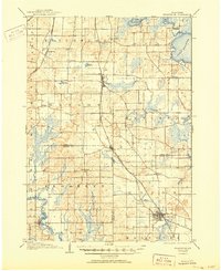
1906 Map of Evansville
USGS Topo · Published 1950About this map
Evansville serves as the primary hub in the southeastern corner of this landscape, where the Chicago and Northwestern Line intersects with local commerce at the beginning of the twentieth century. The terrain is defined by the glacial hydrology of the Yahara River system, flowing through Lake Waubesa and the broad expanse of Lake Kegonsa in the northeast. This 1904 survey reveals a transition from these large water bodies to the rolling agricultural lands of Fitchburg and Oregon.
Find a feature on this map
41 named features on this map. Tap any name to fly to it.
Don’t see what you’re looking for? This feature index may not catch every label — zoom into the map to look around manually.
Map Details
Editions of this 1906 Evansville Map
3 editions found

Other maps of this area

1889 · Evansville
USGS Topo · 1:62,500

1890 · Madison
USGS Topo · 1:62,500

1890 · Sun Prairie
USGS Topo · 1:62,500

1890 · Stoughton
USGS Topo · 1:62,500

1891 · Janesville
USGS Topo · 1:62,500

1892 · Madison
USGS Topo · 1:62,500

1893 · Janesville
USGS Topo · 1:62,500

1893 · Brodhead
USGS Topo · 1:62,500

1894 · Evansville
USGS Topo · 1:62,500

1896 · Sun Prairie
USGS Topo · 1:62,500