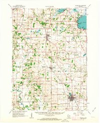
1961 Map of Evansville
USGS Topo · Published 1963About this map
Evansville sits as the primary hub at the southern edge of this landscape, where the Chicago and North Western rail line cuts through a mix of terminal moraine and outwash plains. The map reveals a dense network of mid-century rural institutions, including the Wisconsin School for Girls near Oregon and numerous one-room schoolhouses like Peterson Sch and Jug Prairie Sch that served local farming families.
Find a feature on this map
69 named features on this map. Tap any name to fly to it.
Don’t see what you’re looking for? This feature index may not catch every label — zoom into the map to look around manually.
Map Details
Editions of this 1961 Evansville Map
2 editions found
Other maps of this area

1889 · Evansville
USGS Topo · 1:62,500

1890 · Madison
USGS Topo · 1:62,500

1890 · Sun Prairie
USGS Topo · 1:62,500

1890 · Stoughton
USGS Topo · 1:62,500

1891 · Janesville
USGS Topo · 1:62,500

1892 · Madison
USGS Topo · 1:62,500

1893 · Janesville
USGS Topo · 1:62,500

1893 · Brodhead
USGS Topo · 1:62,500

1894 · Evansville
USGS Topo · 1:62,500

1896 · Sun Prairie
USGS Topo · 1:62,500