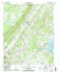
1973 Map of Evensville
USGS Topo · Published 1996About this map
Cumberland Escarpment and Walden Ridge dominate the topography of this Rhea County corridor, where the land drops sharply toward the Tennessee River valley. The settlement pattern follows the valley floor, centered on Evensville and the northern outskirts of Dayton. A network of family-named cemeteries, such as Pierce Cem, Howerton Cem, and Webb Cem, reflects the long-standing agricultural roots of the area.
Find a feature on this map
71 named features on this map. Tap any name to fly to it.
Don’t see what you’re looking for? This feature index may not catch every label — zoom into the map to look around manually.
Map Details
Editions of this 1973 Evensville Map
3 editions found
Other maps of this area

1886 · Cleveland
USGS Topo · 1:125,000

1887 · Kingston
USGS Topo · 1:125,000

1888 · Chattanooga
USGS Topo · 1:125,000

1891 · Kingston
USGS Topo · 1:125,000

1892 · Pikeville
USGS Topo · 1:125,000

1892 · Cleveland
USGS Topo · 1:125,000

1893 · Chattanooga
USGS Topo · 1:125,000

1893 · Kingston
USGS Topo · 1:125,000

1895 · Cleveland
USGS Topo · 1:125,000

1895 · Pikeville
USGS Topo · 1:125,000