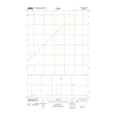
2010 Map of Everdell
USGS Topo · Published 2010About this map
Everdell sits at the heart of this agricultural landscape in Wilkin County, defined by a rigid grid of rural roads and the winding course of the Otter Tail River. The terrain is predominantly flat, partitioned into large sections by local thoroughfares such as County Hwy-18 and County Hwy-16. This 2010 survey reflects a period of modern rural organization where the traditional township structure is clearly visible through the numerical road designations like T-214 and T-196. Aside from the small cluster of buildings at the settlement, the Yaggie Airport serves as a notable landmark for regional aviation. The Otter Tail River meanders across the southern portion of the quadrangle, providing a natural break in the otherwise geometric survey lines and supporting the drainage needs of the surrounding farmland.
Find a feature on this map
31 named features on this map. Tap any name to fly to it.
Don’t see what you’re looking for? This feature index may not catch every label — zoom into the map to look around manually.
Map Details
Editions of this 2010 Everdell Map
This is the sole edition of this map. No revisions or reprints were ever made.
Other maps of this area

1904 · Wahpeton
USGS Topo · 1:125,000

1919 · Rothsay
USGS Topo · 1:62,500

1951 · Rothsay
USGS Topo · 1:62,500

1951 · Campbell
USGS Topo · 1:62,500

1953 · Fargo
USGS Topo · 1:250,000

1956 · Fargo
USGS Topo · 1:250,000

1964 · Wahpeton
USGS Topo · 1:24,000
1973 · South of Wahpeton
USGS Topo · 1:24,000
1973 · Wahpeton NE
USGS Topo · 1:24,000
1981 · Rothsay NW
USGS Topo · 1:24,000