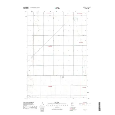
2019 Map of Everdell
USGS Topo · Published 2019About this map
The settlement of Everdell serves as the focal point for this section of Wilkin County, situated near the southern edge of the survey area. This landscape is defined by the highly structured agricultural grid of the Red River Valley, where the natural course of the Otter Tail River in the southwest corner contrasts with the engineered precision of regional water management. Local drainage is facilitated by a system of man-made waterways, including County Ditch Number Thirty One, County Ditch Number Three-Three, and County Ditch Number Three-Two. Transport is primarily conducted via a network of numbered section-line roads such as Co Rd 169 and Co Hwy 17, while the presence of the Yaggie Private Airport north of the townsite highlights the ongoing importance of rural aviation in this agricultural heartland.
Find a feature on this map
41 named features on this map. Tap any name to fly to it.
Don’t see what you’re looking for? This feature index may not catch every label — zoom into the map to look around manually.
Map Details
Editions of this 2019 Everdell Map
This is the sole edition of this map. No revisions or reprints were ever made.
Other maps of this area

1904 · Wahpeton
USGS Topo · 1:125,000

1919 · Rothsay
USGS Topo · 1:62,500

1951 · Rothsay
USGS Topo · 1:62,500

1951 · Campbell
USGS Topo · 1:62,500

1953 · Fargo
USGS Topo · 1:250,000

1956 · Fargo
USGS Topo · 1:250,000

1964 · Wahpeton
USGS Topo · 1:24,000
1973 · South of Wahpeton
USGS Topo · 1:24,000
1973 · Wahpeton NE
USGS Topo · 1:24,000
1981 · Rothsay NW
USGS Topo · 1:24,000