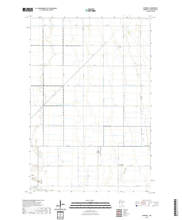
2022 Map of Everdell
USGS Topo · Published 2022About this map
Everdell sits at a crossroads in the Red River Valley, where the grid of Wilkin County meets a highly managed hydrologic landscape. This agricultural corridor is defined by an extensive network of drainage infrastructure, including County Ditch Number Thirty-One and County Ditch Number Three-Three, which channel water across the flat prairie terrain. In the southern reach of the map, the Otter Tail River meanders naturally, providing a sharp contrast to the straight lines of the surrounding section roads and ditches. The presence of the Yaggie Private Airport northwest of the main settlement reflects the intersection of traditional farming and modern logistics. Researchers can trace the precise boundaries of townships like t133n r46w and t132n r45w, which underpin the land ownership patterns of this western Minnesota region.
Find a feature on this map
21 named features on this map. Tap any name to fly to it.
Don’t see what you’re looking for? This feature index may not catch every label — zoom into the map to look around manually.
Map Details
Editions of this 2022 Everdell Map
This is the sole edition of this map. No revisions or reprints were ever made.
Other maps of this area

1904 · Wahpeton
USGS Topo · 1:125,000

1919 · Rothsay
USGS Topo · 1:62,500

1951 · Rothsay
USGS Topo · 1:62,500

1951 · Campbell
USGS Topo · 1:62,500

1953 · Fargo
USGS Topo · 1:250,000

1956 · Fargo
USGS Topo · 1:250,000

1964 · Wahpeton
USGS Topo · 1:24,000
1973 · South of Wahpeton
USGS Topo · 1:24,000
1973 · Wahpeton NE
USGS Topo · 1:24,000
1981 · Rothsay NW
USGS Topo · 1:24,000